Jump To:
Zoning is a legal instrument to regulate the use of land, building size, height, and setbacks. Zoning is intended to promote an orderly pattern of development and to separate land uses that are incompatible such as industrial uses and homes.
The official zoning map is a legal document maintained by the Planning and Development Department that defines the zoning for all areas within the City’s jurisdiction. Every parcel of land within the City’s jurisdiction, including parkland, has a zoning designation. The spatial designations in the official zoning map are known as zoning districts.
To determine the current zoning for a specific property, please try the Find My Zoning web page.
Raleigh's Zoning Districts
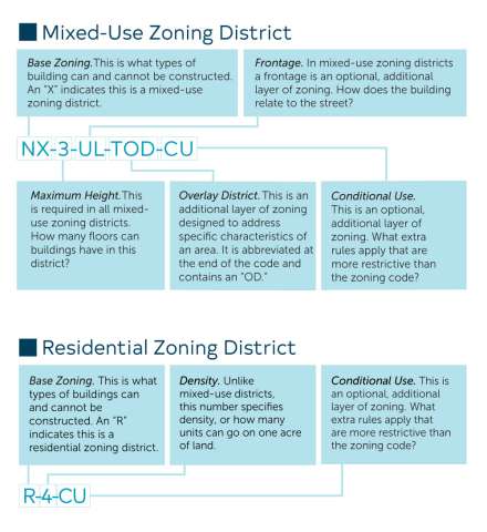
The City of Raleigh uses three types of base zoning districts: residential districts, mixed-use districts, and special districts. Raleigh’s entire jurisdiction is covered by base districts, and there may only be one base district on any parcel. Some parts of the city receive further regulation in the form of overlay districts. More than one overlay district may apply to the same parcel. You can find more information about zoning districts in Raleigh’s Unified Development Ordinance (UDO).
Residential Districts:
Residential districts are designed for neighborhoods with densities of up to 10 dwelling units per acre and building heights no taller than three stories and 40 feet. They allow residential uses as well as civic uses like schools and churches.
Mixed-use Districts:
Mixed-use districts offer greater flexibility in use and density while still allowing for appropriate transitions between residential, commercial, and industrial areas. Lower intensity districts like Residential Mixed Use (RX), Office Mixed Use (OX), and Office Park (OP) restrict the amount of retail use in a development and are intended to provide an active but compatible buffer for residential districts. Neighborhood Mixed Use (NX), Commercial Mixed Use (CX), and Industrial Mixed Use (IX) allow a greater range and concentration of uses, making them well-suited to commercial centers and corridors.
Special Districts:
In addition to residential and mixed-use districts, Raleigh has a set of special districts for areas and uses that require customized regulation. Special districts can address the unique needs of sensitive environmental areas, agricultural uses, or heavy industry.
Overlay Districts:
The last type of zoning district used by the City of Raleigh is the overlay district. Overlays add an extra set of regulations related to an environmental, cultural, or infrastructure feature that may extend across numerous parcels and various base districts.