wake brt

Wake BRT: FAQs


Jump To:

 
What is Bus Rapid Transit (BRT)? Why is Wake County investing in BRT? What is the Wake Transit Plan, and how does it relate to BRT? How does BRT fit into Raleigh’s existing transportation network? Where are the BRT corridors? What will BRT stations look like? Southern Corridor FAQs What is the project timeline? Western Corridor FAQs How can I get involved or provide feedback? Where can I find ongoing updates?

What is Bus Rapid Transit (BRT)?

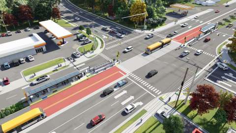
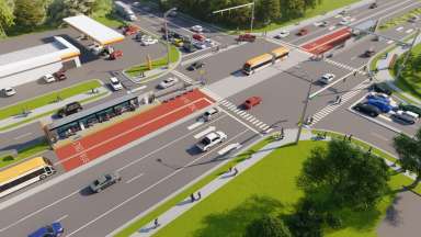
Bus Rapid Transit (BRT) is an enhanced public transportation service that uses dedicated bus lanes, signal priority, and upgraded stations to offer faster, more reliable, and more frequent service than a traditional bus route. BRT makes travel across Raleigh easier, safer, and more convenient.

Please visit this page for an in-depth description of Bus Rapid Transit:
 What is BRT (Bus Rapid Transit) 

Why is Wake County investing in BRT?

Raleigh and Wake County are growing rapidly—and so is the need for efficient, high-capacity, sustainable mobility. BRT supports that growth by:

  • Reducing traffic congestion
  • Expanding access to jobs, schools, and services
  • Improving safety and reliability
  • Offering more transportation options for everyone, including those who do not drive

In 2016, Wake County voters approved a half-cent sales tax to fund the Wake Transit Plan which expands and improves public transit countywide.

What is the Wake Transit Plan, and how does it relate to BRT?

The Wake Transit Plan is a voter-approved program that funds major transit improvements across Wake County through a local sales tax. You can view the current 2035 Plan here.

BRT is one of its cornerstone projects, delivering fast, high-capacity service along key corridors linking downtown Raleigh to surrounding communities, and thus supporting the four “Big Moves” of the Wake Transit Plan: 

CONNECT The region

CONNECT All Wake County communities

PROVIDE Frequent, reliable urban mobility

ENHANCE Access to transit

How does BRT fit into Raleigh’s existing transportation network?

BRT will complement existing GoRaleigh, GoTriangle, and GoCary bus routes, as well as bike facilities and sidewalks. Riders will be able to:

  • Transfer easily between BRT and local bus routes
  • Walk or bike to stations with improved sidewalks and trails
  • Use park-and-ride lots where available

Where are the BRT corridors?

The Wake BRT network currently includes four corridors:

  • New Bern Avenue – under construction
  • Southern Corridor – in design
  • Western Boulevard – in design
  • Northern Corridor – in planning
    • The Northern Corridor will include two BRT routes, one to Midtown/North Hills and one along Capital Blvd to Triangle Town Center

Each line connects downtown Raleigh with major destination areas, improving mobility across the city and region.

More details:
Bus Rapid Transit (BRT) Projects | Raleighnc.gov

What will BRT stations look like?

Wake BRT Station Concept

BRT stations will feature modern, accessible designs with:

  • Shelters, lighting, and seating
  • Real-time arrival displays
  • Level boarding platforms for faster, easier access
  • Ticket vending machines and touchscreen displays
  • Opportunities for integrated public art

Southern Corridor FAQs

Where is the Southern Corridor located?
The Southern Corridor will extend from downtown Raleigh to Garner, serving communities and destinations along South Wilmington Street and Fayetteville Road. 

Maps and updates are available on the Wake BRT: Southern Design and Construction page. 

Will the project require new right-of-way or affect private property?
Most improvements will occur within the existing public right-of-way. In limited cases where small portions of property are needed for sidewalks, stations, or safety improvements, the City will contact property owners directly to discuss next steps.

Learn more about property impacts and resources! 

What will BRT stations look like?
BRT stations will feature modern, accessible designs with:

  • Shelters, lighting, and seating
  • Real-time arrival displays
  • Level boarding platforms for faster, easier access
  • Ticket vending machines and touchscreen displays
  • Opportunities for integrated public art

Final station designs will be shared on the project website as they are completed.

Will there be new sidewalks, bike lanes, or trail connections?
Yes. The Southern Corridor will improve pedestrian and bicycle access by:

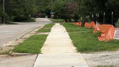
  • Filling sidewalk gaps where feasible
  • Widening sidewalks or creating shared-use paths in key areas
  • Enhancing trail shoulders and bike facilities for safe, multimodal travel

These improvements are being coordinated with City staff to ensure consistent, accessible connections to BRT stations.

What is the project timeline?

PhaseKey ActivitiesTarget Year
DesignFinal design and stakeholder coordinationThrough 2026
ConstructionBegin corridor and station construction2028*
Service LaunchBRT service begins2028–2029*

*Timing depends on federal funding and final design milestones.

Western Corridor FAQs

Where is the Western Corridor located?

The Western Corridor will extend between downtown Raleigh and downtown Cary, serving communities and destinations along Western Boulevard, Cary Town Boulevard, Maynard Road, and Chatham Street.

Maps and updates are available at:
Wake BRT: Western Design and Construction | Raleighnc.gov

Will the project require new right-of-way or affect private property?

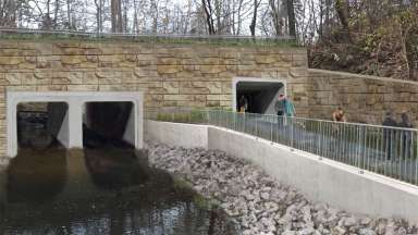
Yes. Most improvements will occur within existing public right-of-way, but some private property will be impacted. Most of these impacts will be small portions of property needed for sidewalks, stormwater infrastructure, or other improvements. 

Some properties will be impacted much more significantly, predominantly those along the Western Blvd Extension. This is a new road segment that is being constructed as a part of the Western BRT to connect Jones Franklin Rd to Bashford Rd and Saddle Seat Dr (and can be seen on the Public Meeting Maps).

The City will contact property owners to discuss a purchase after the 60% design milestone and National Environmental Policy Act (NEPA) work has been completed.

Will there be new sidewalks, bike lanes, or trail connections?

Yes. The Western Corridor will improve pedestrian and bicycle access by:

  • Filling sidewalk gaps where feasible
  • Widening sidewalks or creating shared-use paths in key areas
  • Enhancing trail shoulders and bike facilities for safe, multimodal travel

These improvements are being coordinated with City staff to ensure consistent, accessible connections to BRT stations.

What is the project timeline?

PhaseKey ActivitiesTarget Year
DesignFinal design and stakeholder coordinationThrough 202
ConstructionBegin corridor and station construction2029*
Service LaunchBRT service begins2022 – 2033*

*Timing depends on federal funding and final design milestones.

How can I get involved or provide feedback?

How can I get involved or provide feedback?

Residents can share feedback through:

  • Open houses and community meetings
  • Online surveys and comment forms
  • Project updates available in English and Spanish

Accessibility and translation services are available upon request.
Accessibility | Raleighnc.gov

Where can I find ongoing updates?

All maps, designs, meeting materials, and project news are posted online:
Wake BRT: Western Design and Construction | Raleighnc.gov

Contact


BRT Program Manager
Melanie Rausch
melanie.rausch@raleighnc.gov
919-996-2291
Contact Melanie with any questions about BRT.

BRT Transit Planner
Gabriel Wilkins
Gabriel.wilkins@raleighnc.gov
919-996-3648

Department:
TransportationPlanning and DevelopmentEngineering Services
Service Categories:
Public TransportationPlanning
Related Services:
What is BRT (Bus Rapid Transit)

Subscribe


Related Projects

  All projects
Scroll to top