Jump To:
Know Before You Go
As a recreational UAS pilot, you must comply with all flight rules as established by the Federal Aviation Administration.
Recreational users may fly in Raleigh Parks properties if the following conditions are met:
- Comply with all local, state, and federal laws;
- Register your model aircraft
- Fly within visual line-of-sight
- Follow community-based safety guidelines and fly within the programming of a nationwide community-based organization
- Fly a drone under 55 lbs. unless certified by a community-based organization
- Never fly near other aircraft
- Never fly near emergency response efforts
- Not take off or land UAS in Raleigh parks outside of designated park hours; and,
- Not operate to harass wildlife or members of the public.
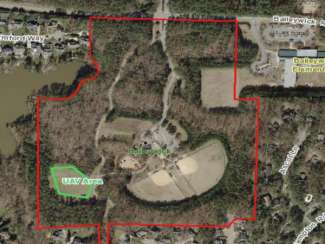
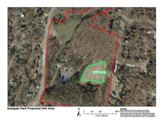
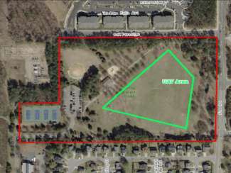
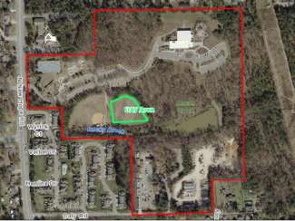
UAS (Drones) weighing less than 400 grams may take off and land in any Raleigh Park except for nature preserves, lakes, wetland centers, or cemeteries. UAS (Drones) weighing more than 400 grams should take off and land from the park locations listed below.
Before flying your drone, be sure to check the area on the B4UFLY Map. Once you enter the location address, click on the map to identify all possible air traffic restrictions including airport/heliports you may need to contact before flight.
Model Rocketry
- Observe and abide by the National Association of Rocketry Safety Code and Safety Zone Requirements;
- Not launch in unsafe weather conditions or when wind speeds are greater than 20 miles per hour;
- Ensure launch sites must have a diameter of at least 400 feet free of any obstructions, including trees, structures, play equipment and should be level;
- Operate a safe distance from park users;
- Utilize single rocket engines size “A” or “B”; and,
- Be responsible for disposing of all trash associated with the activity.
If you have any questions, comments or suggestions for UAS (Drones) in the Raleigh Parks System, please contact prcontact@raleighnc.gov at 919-996-3285.
Restricted Spaces
Drones may not take off or land in any of the following spaces:
Nature Preserves
- Annie Louise Wilkerson, MD Nature Preserve Park
- Durant Nature Preserve
- Horseshoe Farm Nature Preserve
- Walnut Creek Wetland Park