Rain falling near a tree with green leaves

Tropical Storm Debby: Impacts on Raleigh

Preparation Information and Updates

Everything You Need to Know

Updates on Weather and Conditions

Flooding Update: 
Wednesday, August 8, 12:30 p.m.

Road flooding is predicted to occur on Rose Lane, Noble Road, Oxford Road, Atlantic Avenue near Hodges Road, and Crabtree Boulevard on Thursday, August 8. Please proceed with caution and do not drive through flooded waters. Other localized road flooding may occur.

Weather Update: 
Tuesday, August 7, 10 a.m.

Based on the National Weather Service's most recent update, there are potential severe weather impacts for Central N.C., including the greater Raleigh area. 

Tropical Storm Debby could bring:

  • Widespread heavy rain and flooding
  • Gusty winds
  • Potential tornadoes

For more up-to-date information, please visit the National Weather Service site.


Stay informed and who to call:

Contact information - non-emergency, downed trees, clogged storm drains, etc. 

City Service and Department Updates - Cancellations, Closures, and Notices

Parks, Recreation, and Cultural Resources
Update August 7, 4 p.m.

Field status: Code Red 
*all outdoor field activity is postponed.

Field status is updated daily around 4 p.m. Monday through Friday and around 7 a.m. Saturday and Sunday.  Please check the weather line for status updates throughout the day: 919-996-6575.  Coaches and or team managers, any changes in field status beyond this point will be communicated to you through your league administrator. 

Transportation
Update August 7, 3 p.m.

Scooters in the downtown area are being removed and will remain off until Friday evening, August 8.

City Meetings

For meeting cancellations or postponements, visit our Events feed.

Safety Message


The safest thing to do during the storm is stay home. Do that if you can! 

If you must be out and about: 

  • Don't drive through flooded roads.
  • Don't drive around barricades.
  • Be vigilant of fallen debris and power lines.
  • If there is a tornado warning, seek shelter IMMEDIATELY.

Communications

non-emergency graphic

Ways to Stay Informed and Who to Call:

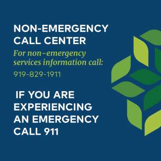
Non-emergency Hotline:

The City has a non-emergency hotline. The number is 919-829-1911.  This is the number to call to report downed trees, which can happen during weather events like Tropical Storm Debby.

Clogged Storm Drains:

Report clogged storm drains and catch basins by completing a Storm Drainage Problem Form or calling 919-996-6446.

Wireless Emergency Alerts (WEAs):

Turn on Wireless Emergency Alerts

Ready Wake Alerts: 

Sign up for Ready Wake alerts.

Twitter:

The City of Raleigh will be updating its Twitter feed: @RaleighGov. This feed features links to any news releases and alerts issued by the City of Raleigh.

Potential Tornadoes

Tornado Watch vs. Warning:

Tornado watch:  Be Prepared! Tornadoes are possible. It’s an early heads-up that tornado-producing storms may form soon.

Review and discuss your emergency plans and check supplies and your safe room. Be ready to act quickly if a warning is issued or you suspect a tornado is approaching. Acting early helps to save lives! The watch area is typically large, covering numerous counties or even states.

Tornado warning: Take Action! A tornado has been sighted or indicated by weather radar. There is imminent danger to life and property. 

Move to an interior room on the lowest floor of a sturdy building, away from the windows. If in a mobile home, a vehicle, or outdoors, move to the closest substantial shelter and protect yourself from flying debris.

More information on what to do before, during, and after a tornado

Know Your Flood Risks

Protecting People and Property During Flood Events

When the city experiences intense rainfall in short durations, there are often rapid rises in creek levels and streambank flooding. A property that is in or near a flood-prone area, or Special Flood Hazard Areas (SFHA), may experience impacts, like flooding, from these storm events.

Flooding happens naturally and cannot be completely prevented. Having measures in place if you experience hazardous flooding or water damage can save lives and valuable assets. It’s important to know your flood risk before a storm comes.

Read more about flood risks.

Tracking With Stormwater

Raleigh Stormwater is monitoring weather conditions across the city. Monitoring helps us plan for the storm, which can bring intense rain in a short period of time. This is especially helpful since we can’t prevent flooding – we can do as much as possible to prepare and reduce impacts.

Flood Monitoring Tools

  • Stream gauges that track how high water gets in creeks. This helps us see how close water is to the road.  
  • Cameras allow us to see road flooding in real-time. We notify first responders to check or barricade the area when water reaches the road.
  • Yellow flood warning signs flash when water reaches the road. Use caution when you see these signs flashing.  
  • Safely lower water levels at Lake Johnson before a storm to reduce flooding impacts downstream.

Track Storms with Us

Prepare for the Storm

emergency management checklist

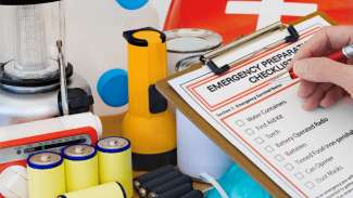
What do I need in an emergency? 

The City is helping residents be connected, prepared, and informed about natural disasters and other emergencies. The City has put together the Ready Raleigh Emergency Preparedness Guide to promote resilience to emergencies at the household and community level. 

The Preparedness Guide has a dynamic table-of-contents. Clicking on a topic in the table will take you to the related content within the document.

Other preparedness resources are listed below in the blue box.

Ready Raleigh Emergency Preparedness Guide


Windy.com (embed)

Additional Resources

Communications 
Emergency Management


Stay informed and who to call:

Contact information - non-emergency, downed trees, clogged storm drains, etc. 

Subscribe