Oaky Grove Methodist Church, ca. 1910. Photo courtesy of Triangle Land Conservancy.

Planning

Southeast Special Area Study

Future Strategies for Raleigh’s Urban Service Area

The City Council adopted the recommendations of the Southeast Special Area Study at the April 4, 2023 meeting. The Final Report and Comprehensive Plan Amendment (CP-12-21) are the result of public engagement between 2019 and 2021.


What’s next?

The City Council authorized expansion of the extraterritorial jurisdiction (ETJ) into the Southeast Special Study Area (SESSA). View a brief video below about ETJ Expansion in the Southeast Special Study Area.

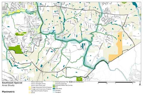
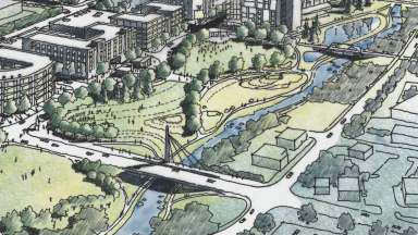
The Southeast Special Area Study is a planning project focused on the future land use, conservation and natural resources, transportation, and public utility infrastructure of approximately 18 square miles in southeast Wake County. The study area is roughly bounded by southeast Raleigh, Wake County’s boundary with Johnston County, Poole Road, Smithfield Road, and Old Baucom Road.  One of the largest area studies ever undertaken by the City of Raleigh, the Study Area encompasses an area roughly the size of the Town of Chapel Hill, NC (see Growth and Extent Comparison). 

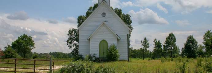
The 'cover' image on this page is a photograph of the Oaky Grove Methodist Church, ca. 1910. This church is now part of the Sarah and Bailey Williamson Preserve, owned by the Triangle Land Conservancy, who provided the photo.

Project Details

 
Type:
Area Plans
Project Lead:
Hannah Reckhow, Senior Planner

Contact


Hannah Reckhow
Planning Supervisor
Planning and Development
hannah.reckhow@raleighnc.gov
919-996-2622


Lead Department:
Planning and Development
Service Unit:
Planning

Subscribe


Strategy

Why do a Southeast Study?

The Southeast Special Area Study is a response to guidance from the 2030 Comprehensive Plan. The Plan influences development and conservation decisions through policies such as the Future Land Use Map, which describes the desired future land use. In this map, several Special Study Areas are identified as areas that will require more focused community outreach to determine the preferred land use pattern. The Southeast Study is focused on one of the Special Study Areas. 

In addition, the study area is experiencing changing conditions that make the time ripe for thoughtful planning. Located at the periphery of several cities and towns – including Raleigh, Garner, Knightdale, Wendell, and Clayton – what is now rural in nature will be affected by the nearby growth and development. This includes growing infrastructure, such as public and private utilities and transportation projects like the I-540 connection. Major questions arise as to how this growth will affect natural resources inside the study area, including the Neuse River, N.C. Mountains-to-Sea Trail, State-recognized natural and cultural heritage sites, and remaining active agricultural land. The goal of this planning process is to involve the community in shaping a response to these changing conditions. 

Lead Department:
Planning and Development

Visioning

Understanding the Study Area – Community Engagement Phase One 

The first phase of the project involved research and discussion of the study area to establish a common understanding of the issues and challenges faced. Discussions among city departments, nearby municipalities, the county, and stakeholder organizations helped establish a foundation of information on existing conditions and known projects and opportunities on the horizon. This phase was concluded in September 2019 and included community listening sessions and an online survey. 

Read the Briefing Book. View the Community Meeting Presentation. See the results of the Summer 2019 survey

Community Ideas and Options – Engagement Phase Two 

This phase built on a shared understanding of the study area and considered ideas for land use, natural resources, transportation, and other issues. The input of residents and stakeholder groups was integrated through public meetings and an online survey conducted during Winter 2020. This brief video details the questions asked in the survey. 

Lead Department:
Planning and Development

Planning

Final Recommendations

The final phase of the study presented a draft of the Executive Summary and the Final Report. The draft recommendations were presented to the public at a series of meetings in June and July 2021 and feedback was received via an online survey. A summary of this phase of engagement is included in the Final Report.

Phase Contacts


Hannah Reckhow

Senior Planner

919-996-2622


hannah.reckhow@raleighnc.gov

Lead Department:
Planning and Development

Southeast Special Area Map

Community Engagement

Engagement with the community of landowners and residents of the SESSA is the cornerstone of this study. The all phases of community engagement are available in the past engagement box at the bottom of the page. 

Engagement will still happen after the study is adopted by City Council and implementation of the study’s recommendations begins.

Get updates on future engagement opportunities by subscribing to Southeast Study (see sign-up box) for more information on the study. Check this page or follow us on social media (FacebookTwitter, or Instagram) to receive notifications once dates are set.

Why do a Southeast Study?

The Southeast Special Area Study is a response to guidance from the 2030 Comprehensive Plan. The plan influences development and conservation decisions through policies such as the Future Land Use Map, which describes the desired future use of a property. In this map, several Special Study Areas are identified as areas that will require more focused community outreach to determine the preferred land use pattern. The Southeast Study is focused on one of the Special Study Areas.

In addition, the study area is experiencing changing conditions that make the time ripe for thoughtful planning. Located at the periphery of several cities and towns – including Raleigh, Garner, Knightdale, Wendell, and Clayton – what is now rural in nature will be affected by the nearby growth and development. This includes growing infrastructure, such as public and private utilities and transportation projects like the I-540 connection. Major questions arise as to how this growth will affect natural resources inside the study area, including the Neuse River, N.C. Mountains-to-Sea Trail, State-recognized natural and cultural heritage sites, and remaining active agricultural land. The goal of this planning process is to involve the community in shaping a response to these changing conditions.

Why should I get involved?

Plans such as the Southeast Special Area Study are a way to shape the future of an area. Planning affects many aspects of everyday life – what kind of housing is available, how we get around, the preservation of natural areas, and much more. Your involvement in the process helps build effective recommendations for the study area.