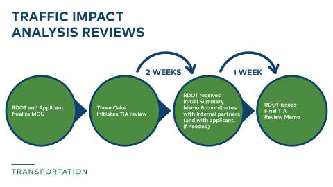
Roundabout at Hillsborough St and Brooks Ave. intersection

Traffic Studies


Jump To:

 
What is a traffic study? When is a traffic study required? How are traffic studies used? How do different kinds of development affect traffic?

Traffic studies are used to evaluate rezoning applications and development plans for traffic impacts and to coordinate related traffic mitigation efforts. Traffic studies are performed by professional engineers who work as consultants to the development community. They are reviewed by City Staff to ensure that Raleigh has a safe, sustainable, efficient, and equitable transportation system. Learn more about traffic studies by viewing the sections below.

What is a traffic study?

Traffic studies evaluate impacts that may be caused by changes in traffic patterns resulting from new development. Where impacts are identified, the study may propose mitigations to support these changes. Mitigations may include new turn lanes, traffic signals, multi-modal improvements, or other transportation demand measures. Specific requirements for traffic studies are provided in the Raleigh Street Design Manual (RSDM), Chapter 7

A traffic study is sometimes called a Traffic Impact Analysis (TIA) or Transportation Impact Analysis.

When is a traffic study required?

Developers may be required to perform a traffic study by the North Carolina Department of Transportation (NCDOT) or by the City. NCDOT has adopted guidelines for when a study should be performed. A key guideline is the daily trips estimated to access the development. If over 3,000 vehicular trips per day are projected to access the development, a study is required.

The City may require a traffic study at the time of a rezoning application or in the process of site planning or subdividing land. The basis for requiring traffic studies is described in Article 8.2 Infrastructure Sufficiency of the City’s Unified Development Ordinance. The specific criteria that trigger a traffic study are listed in Section 7.1.3 of the Raleigh Street Design Manual. Criteria include the number of vehicular trips expected to travel to and from the development during peak travel hours (i.e. ‘rush hours’) as well as site context criteria such as crash history.

How are traffic studies used?

The goals of a traffic study depend on what stage a development is in the process.

Rezoning

The goal of a traffic study as a component of a rezoning application is to determine the impact on the transportation network corresponding to buildout of the property to the highest possible density allowed under the requested rezoning. It is common for the scenario studied in a rezoning traffic study to differ from the type of development that later moves forward, because not every development builds out to the maximum zoning entitlement. The study helps planners evaluate consistency of a rezoning with the Comprehensive Plan, including policies T 1.1 Coordination with Land Use Map and T 2.10 Level of Service. Rather than outlining specific mitigations, the rezoning traffic study provides a universe of potential mitigations that address the identified impacts of the change in zoning. These mitigations are then refined during the site review or subdivision process depending on the specific development program.

Through the rezoning process, the developer may also revise the conditions of their application to reduce potential traffic impacts to limit the scope of potential mitigations. One key strategy to reduce traffic impacts is mixed-use development. 

Site Plan and Subdivision Review

The goal of a traffic study as a component of the site review and subdivision processes is to specifically document the mitigations required to address the actual traffic impacts that are estimated to be imposed by the development. Mitigation must be incorporated into the plans and reviewed by City Staff as a part of the development approval process.

How do different kinds of development affect traffic?

Traffic Engineers rely on the latest edition of the Institute of Transportation Engineers (ITE) Trip Generation Manual to estimate the number of vehicular trips that will occur to and from new development. One of the key insights incorporated into recent editions of the manual is how mixed-use development affects traffic relative to single-use development. When a development includes a combination of residential, retail, commercial, or other uses, some of the trips that would have occurred on the external street network by vehicles instead occur within the development. A resident in a mixed-use development may be able to walk or bike to the nearby grocery store, or walk or bike to work, rather than traveling to another site. The ITE methodology estimates these internal trips in mixed-use development with an ‘internal capture’ calculation and reduces the external trips accordingly. 

Similarly, the context of a site affects how travel to and from the site impacts the overall street network. For example, a new grocery store in an exclusively residential area may reduce overall travel in the area, since residents may substitute a longer trip to a distant grocery store with a shorter trip to the new development. Infill development that is near many other uses generate less new traffic than ‘greenfield’ development of vacant land on the outer edges of the City because travel distances are shorter. The Trip Generation Manual accounts for these differences by providing different rates for different contexts, which fall into three categories: General Urban/Suburban, Dense Mixed-Use Urban, and Center City. City Staff continue to evaluate how best to categorize different areas of Raleigh to select an appropriate context for each study. 

When considering the overall travel generated by a development, infill development is likely to decrease the total vehicles miles travelled (VMT) on the transportation system of existing and future residents by reducing the distance between uses. This reduction has implications for the overall size, maintenance burden, and sustainability of the transportation system, as well as the viability of transportation modes.

Subscribe

 
Lead Department:
Transportation
Service Categories:
Mobility Strategy and Infrastructure