Aerial view of the Western Blvd. and Avent Ferry Rd. Intersection

Planning

Station Area Planning: Western

Connecting neighborhoods to Western BRT

Transit is a means of connecting people with opportunity. It also is a tool for improving sustainability and equity. In a growing city like Raleigh, transit helps people get around in a way that is affordable, supports walkability, and reduces carbon emissions.

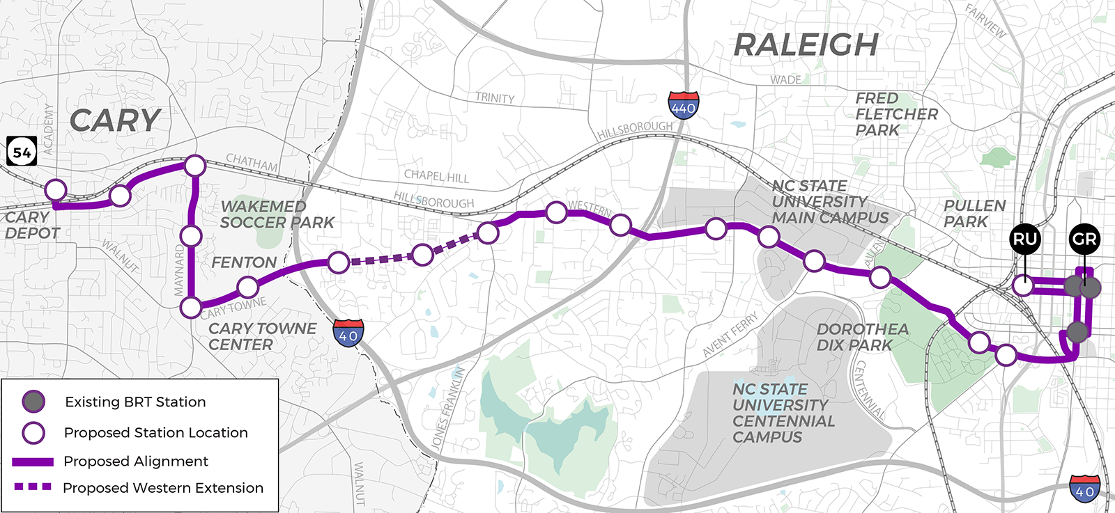
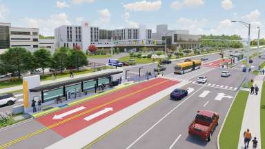
Making the most of a transit investment means thinking about how to grow around transit. Station area planning is the process of planning for future bus rapid transit (BRT) stations. It involves planning for where people will walk and bike to transit and how the areas around Bus Rapid Transit (BRT) stations can grow to support healthy, affordable, and equitable neighborhoods.

This process is separate from the design of the Western BRT stations and bus lanes. It is a community planning process for areas within a short walk of the BRT stations along Western Boulevard but not for the BRT route itself.

Please take a few minutes to share your thoughts on the Western Station Area Planning Options and Concepts Survey. The surveys will close on April 5, 2024, at 11:59 p.m.

Project Details

 
Type:
Corridor Studies
Project Lead:
Sarah Shaughnessy, Senior Planner

Contact


Sarah Shaughnessy
Senior Planner
Planning and Development
919-996-2234
sarah.shaughnessy@raleighnc.gov

Lead Department:
Planning and Development
Participating Department:
Transportation
Service Unit:
Planning

Subscribe


Strategy

Date Range:
-

Area plans are an important part of how the city adapts to change and addresses key issues, such as housing affordability, walkability, and reducing carbon emissions. To learn more about area planning in general, visit the info page. 

Area plans offer a chance to dive deeply into issues and concerns in specific parts of the city. In this case, the focus is on neighborhoods along Western Boulevard.

Wake BRT

In November of 2016, Wake County voters approved a plan for focused investment in public transit which put the implementation of the Wake County Transit Plan in motion. The plan calls for building approximately 20 miles of transit lanes along four Bus Rapid Transit corridors within Wake County: east along New Bern Avenue, south along South Wilmington Street, north (route has not been finalized), and west along Western Boulevard.

Equitable Development Around Transit

To ensure that planning for BRT is thoughtful and equitable, the city undertook the Equitable Development Around Transit study in 2020 to answer two big questions:

  1. To what extent should Raleigh grow more around transit, as opposed to driving, in the future?
  2. How do we ensure the benefits of BRT are shared equitably?

We heard clearly that Raleigh should work toward becoming a much more sustainable and transit-oriented city, and that affordable housing is critical. 

The result of that study, the Equitable Transit-Oriented Development Guidebook, outlines a path toward meeting those goals. It includes strategies and tools for allowing more people to live and work in areas near BRT, to improve housing affordability and choice, and to make it easier and safer to go places by walking or biking.

Western Boulevard Corridor Study

Starting in 2019, the city  undertook a study of the corridor to identify key issues and opportunities for future BRT service. The final report, adopted in 2022, will guide this project.

Lead Department:
Planning and Development

Visioning

Overview

The Western and Southern Bus Rapid Transit (BRT) Corridors have a rich and significant history, particularly for Raleigh’s Black community. As Raleigh plans for BRT service through this part of the city, acknowledging, celebrating, and learning from this history is vital.

In 2022, Planning and Development hired Ari Green, a PhD candidate in American Studies at the University of North Carolina at Chapel Hill, to document the history of these corridors, with a focus on the Black Communities rooted here, whose stories are often untold. This Storymap is the product of extensive research, including archival research, interviews with community leaders, and review of existing planning documents. Please visit the Storymap to learn more.

What’s a Storymap?

A Storymap is an interactive tool that combines maps and data to show and tell stories of a place. This Storymap brings the story of Raleigh’s Western Blvd to life through a presentation of things like historic photos and accounts of past events tied to physical places on a map.

Moving Forward

In documenting and acknowledging the history of the communities along the Western and Southern BRT Corridors, the Storymap also helps us consider how Bus Rapid Transit along Western Boulevard can help respond to some of the past inequities of the communities surrounding Western Boulevard and design infrastructure and services that benefit all of Raleigh’s residents.

Explore the history of the corridor and learn more about what exists today on Western Boulevard. View the “Complicated Legacies: A Deep Dive into Raleigh’s Black Communities Along the Western Bus Rapid Transit Corridor.

Lead Department:
Planning and Development

Planning

Project Scope

The scope for this Station Area Plan includes five key elements:

  • First and last mile mobility
  • Housing affordability and anti-displacement
  • Business support and stabilization
  • Zoning, land use, and urban design
  • Effective and equitable engagement

Engagement

Roughly 73,000 residents from diverse racial, ethnic, and linguistic backgrounds live within a mile of the Western BRT route. The corridor is also home to numerous small businesses and community organizations. To be successful, this project will plan with this corridor community, not just for it.

There will be many opportunities to receive and share information as this project moves forward. Please check back for updates. You can also subscribe for regular email updates through GovDelivery. To do so, add your email address to the subscription box on the right of this page.

Corridor Community Leaders & Connectors

To guide the engagement for this project, City Council has appointed a group of Community Leaders who will:

  • Provide feedback on engagement, education strategies, and materials for public meetings.
  • Confirm that results of the study reflect the everyday experience of living, working, worshiping, shopping, and playing in the community.
  • Share information about the study and reinforce the message that we want to hear from the community.

All Community Leader Group meetings are open to the public. Meeting times and locations will be posted on this project page at least one week prior to the meeting. A link to the meeting minutes will also be available within one week after the meeting.

Additionally, two paid Community Connectors will support this project’s engagement effort. The Community Connectors will be responsible for:

  • Sharing information with the community, as a trusted member of the community.
  • Partnering with staff to develop effective outreach strategies.
  • Gathering information from residents and discussing key issues that are important for the community.

For more information, visit our Western BRT Station Area Planning Community Leaders Group webpage.

Western Station Area Planning Map
Lead Department:
Planning and Development