

Discover how maps, data and technology help communities solve problems
Celebrate 2026 GIS Day with the City of Raleigh on Wednesday, November 18, from 8:30 a.m. to noon at the City of Raleigh Museum, for this interactive event.
GIS, or Geographic Information Systems, is technology that combines maps with location-based information. State and local governments use GIS to plan transportation, manage parks, respond to emergencies, support public services, and better understand the communities they serve.
Visitors will have opportunities to:
- Explore interactive demonstrations.
- Try hands-on GIS activities.
- Learn how government organizations use maps and data.
- Meet GIS professionals and community partners.
- See new and emerging mapping technologies.
- View entries in the 2026 GIS Day Map Contest.
No GIS experience is needed. Whether you work with maps, are interested in technology or simply want to learn how GIS supports the community, everyone is welcome.
Meet Our Participating Organizations
Visit the organizations and teams tabling at GIS Day to learn how they use GIS and related technologies in their work.
4H
Center for Geographic Information & Analysis (Sate of NC)
City of Raleigh Communications Department
City of Raleigh Information Technology- GIS
City of Raleigh Parks and Recreation
City of Raleigh Planning & Development
City of Raleigh Solid Waste Services
City of Raleigh Stormwater
City of Raleigh Transportation Department
City of Raleigh Transit
NCDOT GIS Unit - Information Technology
NC Department of Environmental Quality
Raleigh Water
Town of Cary
Town of Holly Springs IT - GIS Division
Wake County Board of Elections
Wake County Planning and Development Services
Wake County Property Mapping
Wake County Project and Portfolio Management
Wake County Public School System
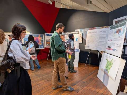
2026 GIS Day Map Contest
The GIS Day Map Contest celebrates creative and informative uses of maps and location-based data. Participants are invited to submit a map that communicates a clear story, explores an issue or shows how GIS can help people better understand their community.
Entries will be reviewed by a panel of judges based on:
- Effective use of GIS and geographic information
- Clarity and accuracy
- Creativity and originality
- Visual appeal
- Community relevance
- Overall effectiveness in communicating a story or idea
Contest details:
- Who may enter: There are student and professional categories
- Entry deadline: November 10 at 5 p.m.
- How to submit: Submit your map file here.
To be eligible, your map submission must be:
- An original work
- Standard size (does not exceed 34” x 44”)
- Printed horizontally (landscape view) AND submit a digital version (.pdf, .jpg, .png)
- Must contain elements generated using GIS-based methods
- Judging Rubric (PDF)
Please bring printed maps to the City of Raleigh Museum on the day of the event.
Explore the power of maps and see how GIS helps turn location-based information into better decisions for Raleigh and communities across North Carolina.
For questions about GIS Day or the map contest, email gisday@raleighnc.gov.