
Jump To:
Speed Limits and Why They Are Important
Setting speed limits is a great tool that we as a city have to help improve the quality of life in Raleigh’s neighborhoods, while also increasing safety in our neighborhoods. There is a direct link between driver speeds and safety, especially for people outside of a vehicle. Pedestrians and cyclists are our most vulnerable users of public streets, and the City of Raleigh is committed to promoting safe streets to ensure that our neighborhoods are happy and healthy.
Lowering the speed limit from the current statutory unposted 35 mph is one of the most impactful things that any neighborhood can do to increase safety and quality of life on their neighborhood street.
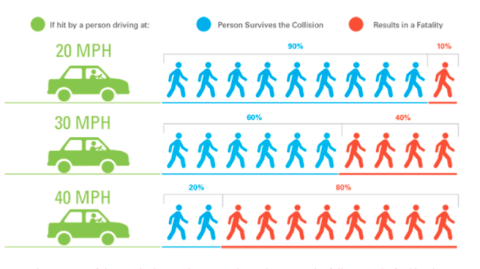
Studies find a direct link between driver speed and severity of the crash when a crash between a pedestrian or cyclist with a vehicle occurs. By lowering speed limits on all of Raleigh’s neighborhood streets, we minimize risk and come closer to our goal of increasing safety in all Raleigh neighborhoods.
To view the context of the graph below, visit the Institute of Transportation Engineers (ITE) for the full report.
Speed Limit Reduction Tracking
Between 2015 and 2025, we have lowered the speed limit on 862 streets which measures out to over 287 miles. Moving forward, we want to continue to increase the number of streets and the miles of streets reduced until all of Raleigh’s neighborhood streets have been successfully reduced.
Yearly Tracking:
2015: 14 streets measuring approximately 4.75 miles
2016: 29 streets measuring approximately 10 miles
2017: 21 streets measuring approximately 7 miles
2018: 35 streets measuring approximately 12.75 miles
2019: 7 streets measuring 2.5 miles
2020: 34 streets measuring approximately 13 miles
2021: 128 streets measuring approximately 54.6 miles
2022: 213 streets measuring approximately 88.28 miles
2023: 186 streets measuring approximately 44.4 miles
2024: 138 streets measuring approximately 34.81 miles.
2025: 57 streets measuring approximately 15.89 miles.
2026: 54 streets measuring approximately 15.36 miles.
Speed Limit Reduction Processing
All streets currently going through the Speed Limit Reduction process are listed below.
If you are interested in requesting a Speed Limit Reduction for your street, subdivision, or neighborhood streets - please submit your request using our Ask Raleigh portal.
Speed Limit Reductions In Process
Wakefield Plantation Neighborhood-Angel Falls Road, Arneson Street, Beauvoir Street, Boone Hall Court, Brandon Hall Drive, Bunchgrass Lane, Caldewood Street, Corvus Road, Crystal Oaks Lane, Draco Road, Dunard Street, Elmfield Street, Fieldland Court, Fieldmist Drive, Herdsman Way, Kaysmount Court, Mayhurst Place, Mountain Ash Court, Penrose Trail, Sargas Street, Schubba Court, Snapswell Street, Stratford Hall Drive, Village Gate Way and White Marsh Drive.
Currently scheduled to be presented to City Council for approval at the January 19, 2027 Council meeting.
Middleton at Wakefield Neighborhood-Browder Street, Camberwell Court, Cilcain Court, Canolder Street, Mabry Mill Street, and Narrawood Street.
Currently scheduled to be presented to City Council for approval at the December 01, 2026 Council meeting.
Westborough Neighborhood-Brumbley Place, Elderson Lane, Finland Drive, Flanagan Place, Fleetwood Drive, Owenston Court, Royal Coach Court, South Side Drive, Sweden Drive, and Thomasville Court.
Currently scheduled to be presented to City Council for approval at the November 17, 2026 Council meeting.
Crossings at Tryon Neighborhood-Yates Mill Trail, Cumberland Pond Road, and Bogle Branch Court.
Currently scheduled to be presented to City Council for approval at the November 03, 2026 Council meeting.
Fieldcross at Eagle Chase and Walnut Ridge Neighborhoods-Fieldcross Court, Kilpeck Lane, Kincross Court, Pineton Court, and Walnut Ridge Court.
Currently scheduled to be presented to City Council for approval at the November 03, 2026 Council meeting.
Gresham Lake Road-West: Rainwater Road to Litchford Road
Currently scheduled to be presented to City Council for approval at the October 20, 2026 Council meeting.
Approved Speed Limit Reductions
All new speed limits will go into effect seven days from Council approval:
Edgemont Drive: Ed Drive to end of City maintenance at private drive
Council approved the speed limit reduction at the October 20, 2026 meeting. Speed limit signs will be put in place and enforceable within 7 days of this approval.
Lansing Street-Parnell Drive to Nelson Street
Council approved the speed limit reduction at the October 20, 2026 meeting. Speed limit signs will be put in place and enforceable within 7 days of this approval.
Valley Estates Drive-Lynn Road to Lead Mine Road
Council approved the speed limit reduction at the October 20, 2026 meeting. Speed limit signs will be put in place and enforceable within 7 days of this approval.
Sellona Street-Globe Road to Globe Road
Council approved the speed limit reduction at the October 20, 2026 meeting. Speed limit signs will be put in place and enforceable within 7 days of this approval.
Carolyn Drive-Brentwood Road to end/cul-de-sac of Carolyn Drive
Council approved the speed limit reduction at the October 20, 2026 meeting. Speed limit signs will be put in place and enforceable within 7 days of this approval.
Ben Bur Road-Lynn Road to Wynbrook Way
Council approved the speed limit reduction at the October 20, 2026 meeting. Speed limit signs will be put in place and enforceable within 7 days of this approval.
Canary Falls Lane-Farm Gate Road to dead end of Canary Falls Lane
Council approved the speed limit reduction at the October 20, 2026 meeting. Speed limit signs will be put in place and enforceable within 7 days of this approval.