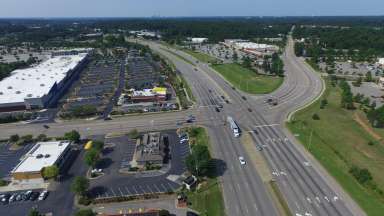
Capital Blvd and Old Wake Forest

Land Use and GHG Emissions


Jump To:

 
How Land Use Determines Transportation Emissions How We Got Here Housing Types and GHG Emissions International Comparison Consider Two Different Neighborhoods What Can We Learn From This Data? Recent Planning in Raleigh

How Land Use Determines Transportation Emissions

Land use laws significantly affect greenhouse gas (GHG) emissions. This is because they shape how we get around and the types of homes that can be built. In the United States, they encourage driving to get from one place to another. If homes are close to workplaces, stores, parks, and schools, then people can travel to those destinations without always driving. Often, however, land use laws require that homes and destinations be far apart from each other. 

Traditionally, cities in the United States grew around walkable downtowns. As streetcars became popular in the late 1800s, walkable, transit-served neighborhoods grew up near downtowns. This is still the case in most cities around the world. However, cities in the United States took a different path over the last century.

How We Got Here

In the early decades of the 20th century, many cities and neighborhoods tried to exclude Black residents from parts of the city. However, Courts overturned explicitly racial land use regulations. In response, cities adopted zoning regulations that made it illegal to build more affordable housing types such as apartments and townhouses. This required residents in these zones - typically, the majority of residential areas in most cities - to be able to afford large yards and a single-unit house. Previously, zoning had been used to separate uses such as slaughterhouses from residential areas. Increasingly, however, they were used to separate residents based on income, which correlated to race.

This approach is described by the U.S. Supreme Court in the landmark Euclid v. Ambler ruling, which allowed cities to prohibit more affordable housing types. The Court, in a split decision that is still the law of the land, wrote that “very often the apartment house is a mere parasite, constructed in order to take advantage of the open spaces and attractive surroundings created by the residential character of the district.”

Banning apartment buildings, townhouses, and small lot detached houses while also making neighborhood retail and restaurants illegal meant that driving became the only option for most Raleigh residents. Even where they are allowed, neighborhood-serving businesses find it hard to survive, because few people live close enough to walk. Instead, “big box” retail, featuring buildings fronted by large parking lots, are the only form that is viable.

At the same time, excitement about new technology – faster cars and “freeways” – created a rush to build wider streets and new highways, often running them directly through city centers and neighborhoods. The implications of this new form of city on social ties, health, and the neighborhoods they passed through were ignored. 

Housing Types and GHG Emissions

Zoning has led to high GHG emissions in a second major way. The kinds of housing types that zoning made illegal in most of our cities – apartments both big and small, townhouses, and duplexes – all use much less energy than detached homes. This is because they share walls and ceilings and because they are smaller on average. 

Making these homes illegal in most places has created higher housing costs. It also contributes significantly to emissions. A townhouse on average uses about two-thirds the amount of energy of a detached house. An apartment unit uses less than half. See more on this topic here.

International Comparison

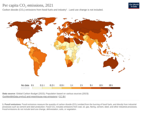
Map showing per capita emissions by country. Emissions in the U.S. are much higher than in other countries with similar levels of development, such as many in Europe or east Asia.

Our World In Data

The difference in GHG emissions between places that allow more people to live in walkable areas served by transit and those that strictly limit how many people can live in a neighborhood are significant. This can be seen by comparing carbon emissions in the United States with other counties with similar levels of development. For instance, the average person in the United States produces more than 13 tons of carbon annually, according to the World Bank. The average person in Switzerland uses less than a third of that amount. 

Consider Two Different Neighborhoods

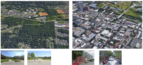
This shows images from two zip codes in the Richmond, Virginia area. One is very suburban, the other is near downtown.
Neighborhood Edge of Richmond Downtown Richmond
Zip Code 23313 23219
Typical Housing Detached houses on large lots Apartments, townhouses, detached houses on small lots
Transit and Walking No transit, walking difficult or impossible due to distance and conditions High levels of transit, walking is easy because distances are short and walking is comfortable and safe
Driving Trips are much longer on average because of distance between typical origins (where people live) and destinations (workplaces, shopping, parks, schools) Trips are shorter on average because origins are close to destinations
GHG Emissions Per Person 68.6 tons per year 24.2 tons per year

What Can We Learn From This Data?

How does this relate to the Climate Action Plan? The data and examples above make it clear that land use policy is climate policy. 

The reality is that the Raleigh-Durham region have been growing rapidly for decades and will continue to do so. That is because Research Triangle Park, major universities, health care systems, state government, and creative entrepreneurs have made this a place where people can come for work and to make a better life. It is also because Raleigh and the region is a diverse, welcoming community for people from everywhere from rural North Carolina to countries across the world.

Given that, there are two main conclusions we can draw:

  • Not allowing denser housing in cities does not mean environmental impacts are avoided. It just means those impacts are in suburban or exurban locations. Those are places where people must drive further, where more trees must be cut down, and where GHG emission per person are several times higher than in Raleigh. In short, new residents will either be allowed to live in energy efficient buildings in walkable places, or they will live in inefficient buildings in places where they cannot walk anywhere.
  • Building more highways and widening streets means more driving. This may be desirable for economic or social reasons. However, climate, health, and other costs should be incorporated into these decisions.

Recent Planning in Raleigh

Raleigh, like many other cities across the country, has begun to remove the zoning barriers that were created to ensure segregation. Raleigh has changed zoning laws to allow more housing types in more places and to allow more people to live and work in walkable areas served by transit. Raleigh has also planned land use around transit investments, including planning for more housing and employment opportunities near bus rapid transit.

It is important to note that these actions have benefits that go beyond climate. Allowing people to live in traditional city environments improves community health by making walking trips much more common. It also improves social ties and supports small businesses, as people are able to walk to neighborhood restaurants or coffee shops, which can’t survive without many customers nearby.

Lastly, these same actions improve housing affordability and add community wealth. Detached houses are the most expensive housing type, and only allowing them makes housing unaffordable for many residents. Allowing more people to live and work in walkable places unlocks the value of urban land and allows the city to fund more services, including subsidized affordable housing.

Contact


Jason Hardin
Jason.Hardin@raleighnc.gov

Department:
Sustainability

Subscribe