Jump To:
Microclimate Modeling and Digital Twin project helps envision Raleigh's future
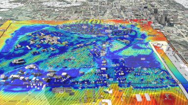
The City of Raleigh’s IT Department in partnership with other departments and an external vendor explored the use of technology in solving current challenges using Microclimate Modeling and Digital Twin to envision Raleigh's future. A digital twin is a virtual model of a physical object. It spans the object's lifecycle and uses real-time data sent from sensors on the object to simulate the behavior and monitor operations.Data from the City project resulted from exploring innovative technology to address the mounting complexities of urban life and climate change. Raleigh took a groundbreaking approach by introducing a digital twin paired with an advanced microclimate modeling system. This innovative solution can guide more intelligent and resilient urban development.
The team crafted a detailed digital replica of Raleigh, with the primary objective of leveraging it to comprehend the microclimate, to provide tools and data-driven evidence demonstrating how urbanization can be executed more securely, making cities more resilient to climate change.
Goals:
- Smarter Decisions: Empowering planners with microclimate insights to make informed choices.
- Clearer Picture: Making complex data visually accessible for everyone, not just the tech-savvy.
- Improved Urban Planning: Facilitating the integration of microclimate data into the urban planning process to optimize designs for enhanced environmental sustainability and resilience.
- Enhanced Public Spaces: Contributing to the creation of more comfortable and livable public spaces by considering real-feel temperatures and wind patterns in the design and placement of amenities.
- Climate-Ready Future: Proactively identifying and mitigating risks like heat islands and wind-related issues.
By addressing these challenges, the initiative positions Raleigh as a leader in smart urban development, presenting a model that could be emulated by other municipalities grappling with similar challenges.
Project Partners
- MITRE’s independent research and development program
- MITRE partnership with Aeris LLC to use its Joint Outdoor-indoor Large Eddy Simulation (JOULES)
- City of Raleigh IT Department
- City of Raleigh Office of Strategy and Innovation
- City of Raleigh Office of Sustainability
- City of Raleigh Office of Planning and Development
City staff partnered and guided the development of the tool for the past year. This includes expertise and subject matter experts from City IT, Sustainability, Strategy and Innovation, Planning and Development. Some staff who conducted previous work on the Digital Twin and Climate Action Plan, provided fresh eyes, innovative minds, and adaptable frameworks that allow for new purposes and expanded usage.
The project team conducted an estimated 40 simulations per city with the model estimating temperature, humidity, and airflow change based on the time of day, larger scale wind direction, changing climate, and different urbanization scenarios. The objective was to illustrate and emphasize the practical application of this data, offering tools and data-driven evidence on how urbanization can be undertaken more safely to enhance cities' resilience to climate change. The City’s Strategy & Innovation Office led the coordination with MITRE's Smart City program. The City’s Sustainability and Planning and Development Offices advised on data positioning for impactful activity, both positive and negative analysis.