Map view in software of a city street in Raleigh counting traffic

Raleigh Highlights Advanced Technology Use at Global Conference

Advanced technology can play a key role in increasing pedestrian and cyclist safety and enhancing transportation. 

Working towards smarter decision making

Advanced technology can play a key role in increasing pedestrian and cyclist safety and enhancing transportation. The City of Raleigh will demonstrate how to do that at a global Smart City conference in Barcelona, Spain, in November.

A “smart city” uses technology and data to improve services, efficiency, and sustainability.

Raleigh is partnering with industry leaders Esri, NVIDIA, and Microsoft on creating smart city solutions. The City is using the companies’ technology to transform how people get around the city. IT Manager James Alberque and partners will present on this work at the Smart City Expo Congress 2025.  

Using the Summarization (VSS) Blueprint with Esri ArcGIS on Microsoft Azure platforms, Raleigh is pioneering the use of artificial intelligence and geospatial data to help optimize transportation options.

“Our goal is to leverage real-time data and AI to optimize traffic flows and enhance pedestrian and cyclist safety,” said  Alberque, whose team is working on the project. “This technology can empower our city departments to collaborate efficiently and make data-driven decisions that benefit all residents.” 

Raleigh’s Smart Mobility Achievements

Map view in software of a city street in Raleigh

Developments that will be presented in the SmartCities conference include: 

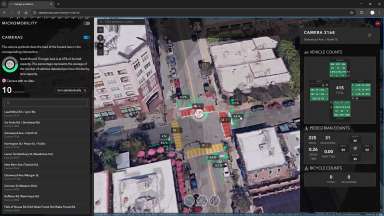
Dynamic Traffic Management
Raleigh uses continuous, around-the-clock data collection to:

  • Inform signal timing
  • Reduce congestion
  • Improve safety for all road users

Data captured is not stored. It is used to create analytics, including trajectories of cars, pedestrians, and bicyclists.

Cross-Department Collaboration
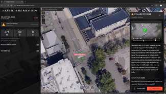
The future goal of this project is to use real-time insights that can be shared across transportation and public safety teams.

Data-Driven Planning
Incorporating data from computer vision models into the City’s digital twin can provide a comprehensive view of urban mobility (how people move around the city). That can support proactive planning and rapid response. That can also enable coordinated responses and efficient resource allocation. 

Expanding Impact

Raleigh’s smart city initiative is expanding beyond transportation. The City plans to extend data-driven solutions to additional departments and fields. By bringing data and analytics together, Raleigh is advancing insights into understanding our city.

“We’re proud to be recognized at the conference in Barcelona as a leader in smart mobility,” Alberque added. “Our partnership with the vendors demonstrates how technology and collaboration can improve quality of life, reduce costs, and build resiliency in our rapidly growing city.”

At this time the City is in the training stage of developing the AI model and the concept for this project. 

Lead Department:
Information Technology

Subscribe