Thank you for printing this page from the City of Raleigh's Official Website (www.raleighnc.gov)
https://raleighnc.gov/stormwater/services/floodplain-regulations/find-floodplain
03/26/2024 12:54 pm
This flooding happens naturally and cannot be completely prevented. It's important to stay safe. Have measures in place if you experience hazardous flooding, water damage, and limited access to and from your home when it rains.
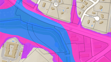
Map: Frequency of Flooding
Use this map to see where flooding typically occurs in Raleigh. The map shows areas in the floodplain and roads that are likely to flood.View the map in a web browser.
Type in your address to see how close you are to these locations.
Watch this video to learn more about the floodplain and the best ways to stay safe. Mira el video en español
What’s a Floodplain?
A floodplain is the area next to a creek or river that floods. Learn about the best ways to stay safe in this area and the natural benefits the floodplain has on the environment.